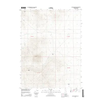
2014 Map of Majuba Mountain
USGS Topo · Published 2014About this map
Majuba Mtn and the surrounding Majuba Mountains dominate this high-desert landscape in Pershing County, where steep elevation changes are defined by narrow drainages like Majuba Canyon. This region is characterized by its vital water sources in a dry environment, including Willow Springs, Abel Spring, and Big Antelope Spring. These isolated springs and the Cavanaugh Wash system dictate the movement of travelers and wildlife between the mountains and the Humboldt Valley to the south. The presence of Pioneer Rd and Antelope Rd indicates the sparse but essential transportation network used to navigate the rugged foothills of the Antelope Range. The mapping reflects a traditional Great Basin topography, where life and travel are strictly governed by the proximity to water and the traversable gaps between mountain peaks.
Find a feature on this map
15 named features on this map. Tap any name to fly to it.
Don’t see what you’re looking for? This feature index may not catch every label — zoom into the map to look around manually.
Map Details
Editions of this 2014 Majuba Mountain Map
This is the sole edition of this map. No revisions or reprints were ever made.
Other maps of this area

1931 · Lovelock
USGS Topo · 1:250,000

1935 · Lovelock
USGS Topo · 1:250,000

1955 · Lovelock
USGS Topo · 1:250,000

1959 · Lovelock
USGS Topo · 1:250,000

1971 · Majuba Mtn
USGS Topo · 1:24,000

1971 · Rye Patch Reservoir South
USGS Topo · 1:24,000

1971 · Poker Brown
USGS Topo · 1:24,000

1971 · Rye Patch Reservoir North
USGS Topo · 1:24,000
1971 · Alpha Mountain
USGS Topo · 1:24,000
1971 · Long Canyon
USGS Topo · 1:24,000