
1971 Map of Rye Patch Reservoir North
USGS Topo · Published 1974About this map
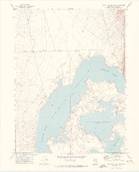
The Humboldt River dominates this northern Pershing County landscape, feeding into a complex network of man-made impoundments. The sheet captures the intricate shoreline of Rye Patch Reservoir and the adjacent Upper Pitt-Taylor Reservoir, showing the precise water levels and topographic contours that defined water management in the early 1970s. To the east, the Eugene Mountains rise abruptly from the basin, providing a stark contrast to the expansive Alkali Flats that border the water's edge.
Find a feature on this map
13 named features on this map. Tap any name to fly to it.
Don’t see what you’re looking for? This feature index may not catch every label — zoom into the map to look around manually.
Map Details
Editions of this 1971 Rye Patch Reservoir North Map
2 editions found
Other maps of this area

1931 · Lovelock
USGS Topo · 1:250,000

1935 · Lovelock
USGS Topo · 1:250,000

1939 · Eugene Mountains Area
USGS Topo · 1:62,500

1942 · Eugene Mountains Area
USGS Topo · 1:62,500

1955 · Lovelock
USGS Topo · 1:250,000

1956 · Imlay
USGS Topo · 1:62,500

1959 · Lovelock
USGS Topo · 1:250,000

1971 · Majuba Mtn
USGS Topo · 1:24,000

1971 · Rye Patch Reservoir South
USGS Topo · 1:24,000

1971 · Poker Brown
USGS Topo · 1:24,000