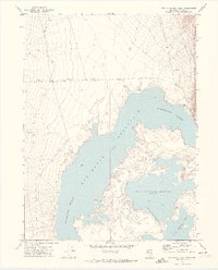
1971 Map of Rye Patch Reservoir North
USGS Topo · Published 1974About this map
Rye Patch Reservoir dominates this high-desert basin, where the Humboldt River is managed through a complex of impoundments in Pershing County. The map details the specific water levels and containment areas of the Upper Pitt-Taylor Reservoir and Lower Pitt-Taylor Reservoir, showing a landscape defined by the tension between vital water storage and the surrounding arid Alkali Flat. To the east, the terrain rises sharply into the Eugene Mountains, providing a stark backdrop to the irrigation infrastructure below. Evidence of human activity beyond water management is sparse but telling, appearing in the form of a remote Prospect and the isolated Nelson Well, connected only by a network of unimproved tracks and a Jeep Trail that cross the alluvial fans.
Find a feature on this map
13 named features on this map. Tap any name to fly to it.
Don’t see what you’re looking for? This feature index may not catch every label — zoom into the map to look around manually.
Map Details
Editions of this 1971 Rye Patch Reservoir North Map
2 editions found

Other maps of this area

1931 · Lovelock
USGS Topo · 1:250,000

1935 · Lovelock
USGS Topo · 1:250,000

1939 · Eugene Mountains Area
USGS Topo · 1:62,500

1942 · Eugene Mountains Area
USGS Topo · 1:62,500

1955 · Lovelock
USGS Topo · 1:250,000

1956 · Imlay
USGS Topo · 1:62,500

1959 · Lovelock
USGS Topo · 1:250,000

1971 · Majuba Mtn
USGS Topo · 1:24,000

1971 · Rye Patch Reservoir South
USGS Topo · 1:24,000

1971 · Poker Brown
USGS Topo · 1:24,000