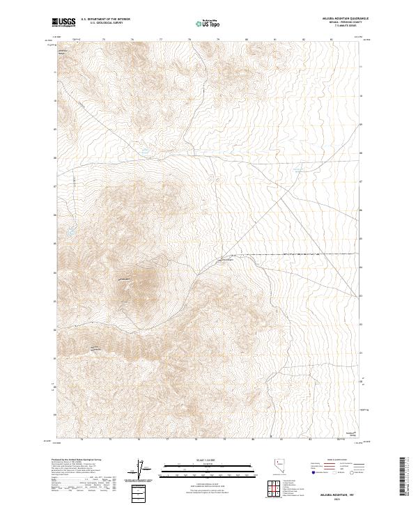
2021 Map of Majuba Mountain
USGS Topo · Published 2021About this map
Majuba Mtn dominates this portion of the Pershing County desert, where steep contour lines reveal the dramatic verticality of the Majuba Mountains. This terrain serves as a significant drainage divide, with Majuba Canyon cutting through the center of the sheet toward the lower elevations of the Humboldt Valley. The presence of scattered water sources like Willow Springs, Abel Spring, and Big Antelope Spring suggests the vital importance of these points for transit and livestock in an otherwise arid landscape.
Find a feature on this map
14 named features on this map. Tap any name to fly to it.
Don’t see what you’re looking for? This feature index may not catch every label — zoom into the map to look around manually.
Map Details
Editions of this 2021 Majuba Mountain Map
This is the sole edition of this map. No revisions or reprints were ever made.
Other maps of this area

1931 · Lovelock
USGS Topo · 1:250,000

1935 · Lovelock
USGS Topo · 1:250,000

1955 · Lovelock
USGS Topo · 1:250,000

1959 · Lovelock
USGS Topo · 1:250,000

1971 · Majuba Mtn
USGS Topo · 1:24,000

1971 · Rye Patch Reservoir South
USGS Topo · 1:24,000

1971 · Poker Brown
USGS Topo · 1:24,000

1971 · Rye Patch Reservoir North
USGS Topo · 1:24,000
1971 · Alpha Mountain
USGS Topo · 1:24,000
1971 · Long Canyon
USGS Topo · 1:24,000