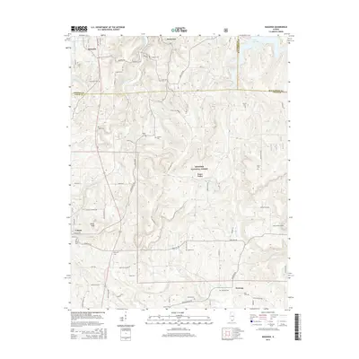
2015 Map of Makanda
USGS Topo · Published 2015About this map
Makanda sits at the northern edge of this Southern Illinois landscape, where the wooded uplands of the Shawnee National Forest meet a complex network of creeks and ridges. The terrain is marked by significant elevation changes, notably at Tiptop Knob and the Water Valley area. For family historians, the sheet is exceptionally dense with burial sites, including the Wilkins Cem, Walker Cem, and the remote Treece Cem tucked within the forest boundaries.
Find a feature on this map
73 named features on this map. Tap any name to fly to it.
Don’t see what you’re looking for? This feature index may not catch every label — zoom into the map to look around manually.
Map Details
Editions of this 2015 Makanda Map
This is the sole edition of this map. No revisions or reprints were ever made.
Other maps of this area

1920 · Jonesboro
USGS Topo · 1:62,500

1920 · Dongola
USGS Topo · 1:62,500

1922 · Carbondale
USGS Topo · 1:62,500

1923 · Dongola
USGS Topo · 1:62,500

1923 · Jonesboro
USGS Topo · 1:62,500

1924 · Alto Pass
USGS Topo · 1:62,500

1941 · Carbondale
USGS Topo · 1:62,500

1947 · Jonesboro
USGS Topo · 1:62,500

1947 · Alto Pass
USGS Topo · 1:62,500
1947 · Cobden
USGS Topo · 1:24,000