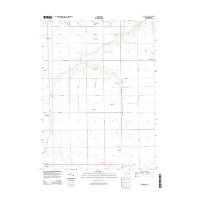
2013 Map of Malinta
USGS Topo · Published 2013About this map
Malinta serves as the central hub of this Northwest Ohio landscape, situated at the intersection of N Henry St and various regional roads. The area is defined by a systematic grid of section lines and county routes, including Co Road M and Co Road 10, which connect the smaller settlements of Grelton, Shunk, and Elery. This geometric organization is occasionally disrupted by the winding paths of Turkeyfoot Creek and South Turkeyfoot Creek, which drain the surrounding agricultural fields.
Find a feature on this map
85 named features on this map. Tap any name to fly to it.
Don’t see what you’re looking for? This feature index may not catch every label — zoom into the map to look around manually.
Map Details
Editions of this 2013 Malinta Map
This is the sole edition of this map. No revisions or reprints were ever made.
Other maps of this area

1908 · Ottawa
USGS Topo · 1:62,500

1908 · Napoleon
USGS Topo · 1:62,500

1909 · Mc Clure
USGS Topo · 1:62,500

1953 · Fort Wayne
USGS Topo · 1:250,000

1956 · Fort Wayne
USGS Topo · 1:250,000

1956 · Toledo
USGS Topo · 1:250,000

1959 · Florida
USGS Topo · 1:24,000
1959 · Napoleon West
USGS Topo · 1:24,000

1960 · Deshler
USGS Topo · 1:24,000
1960 · Napoleon East
USGS Topo · 1:24,000