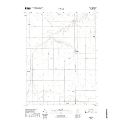
2019 Map of Malinta
USGS Topo · Published 2019About this map
The agricultural landscape of Henry County is defined by a dense grid of township and county roads, punctuated by small settlements like Malinta and Grelton. The meandering path of S Turkeyfoot Cr and its tributaries, such as Lost Cr, break the geometric regularity of the farm plots, creating a network of riparian corridors across the terrain. These waterways historically influenced the placement of rural landmarks, including several historic burial grounds like Kripp Cem and Hope Lutheran Cem. Modern transportation infrastructure is represented by the Henry County Airport located north of Shunk, while the enduring presence of local religious and social centers is evident at Emanuel Lutheran Cem. This survey illustrates the persistence of small-scale rural communities like Elery within a highly organized regional drainage and transport system.
Find a feature on this map
48 named features on this map. Tap any name to fly to it.
Don’t see what you’re looking for? This feature index may not catch every label — zoom into the map to look around manually.
Map Details
Editions of this 2019 Malinta Map
This is the sole edition of this map. No revisions or reprints were ever made.
Other maps of this area

1908 · Ottawa
USGS Topo · 1:62,500

1908 · Napoleon
USGS Topo · 1:62,500

1909 · Mc Clure
USGS Topo · 1:62,500

1953 · Fort Wayne
USGS Topo · 1:250,000

1956 · Fort Wayne
USGS Topo · 1:250,000

1956 · Toledo
USGS Topo · 1:250,000

1959 · Florida
USGS Topo · 1:24,000
1959 · Napoleon West
USGS Topo · 1:24,000

1960 · Deshler
USGS Topo · 1:24,000
1960 · Napoleon East
USGS Topo · 1:24,000