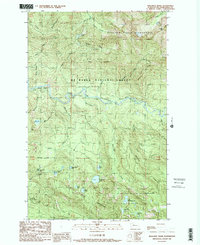
1989 Map of Mallardy Ridge
USGS Topo · Published 1989About this map
The South Fork Stillaguamish River cuts through the center of this mountain landscape, serving as a primary corridor through the Mt Baker National Forest. High ridges such as Mallardy Ridge and Wiley Ridge define the vertical relief of the area, while Bald Mountain dominates the southern skyline. The map documents a transition between active resource management and conservation, as seen in the proximity of a Quarry to protected areas like the Boulder River Wilderness. Recreation is centered around the Gold Basin Campground and an extensive network of alpine waters, including Ashland Lakes, Boardman Lake, and Evan Lake. This late-1980s data highlights the remote character of Snohomish County’s interior, where access is measured by river mile markers like Mile 48 and Mile 55 rather than town centers.
Find a feature on this map
48 named features on this map. Tap any name to fly to it.
Don’t see what you’re looking for? This feature index may not catch every label — zoom into the map to look around manually.
Map Details
Editions of this 1989 Mallardy Ridge Map
This is the sole edition of this map. No revisions or reprints were ever made.
Other maps of this area

1899 · Stillaguamish
USGS Topo · 1:125,000

1901 · Stilaguamish
USGS Topo · 1:125,000

1921 · Sultan
USGS Topo · 1:125,000

1923 · Sultan
USGS Topo · 1:125,000

1955 · Concrete
USGS Topo · 1:250,000

1956 · Monroe
USGS Topo · 1:62,500

1956 · Granite Falls
USGS Topo · 1:62,500

1957 · Silverton
USGS Topo · 1:62,500

1957 · Index
USGS Topo · 1:62,500

1957 · Wenatchee
USGS Topo · 1:250,000