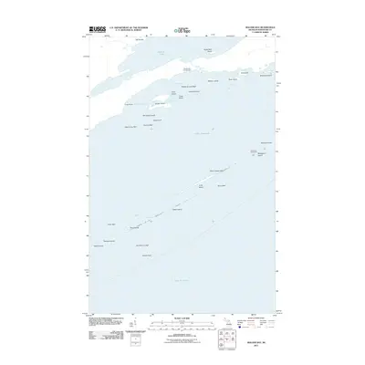
2011 Map of Malone Bay
USGS Topo · Published 2011About this map
Isle Royale Lighthouse stands on Menagerie Island as a sentinel over the hazardous reefs and shoals of southern Isle Royale. This 2011 survey of the maritime landscape reveals a dense archipelago of small landforms, including Wright Island, Malone Island, and the Paul Islands, which fragment the waters between the open Lake Superior and the sheltered Malone Bay. The map captures the transition from the interior freshwater of Siskiwit Lake to the Great Lake via Siskiwit Falls. While largely an uninhabited wilderness within a national park, the area is anchored by the Malone Bay Campground and several natural harbors like Hopkins Harbor and Dog Harbor. The intricate naming of underwater features such as Middle Ground Reef and Glenlyon Shoal underscores the area's significance for navigation and maritime history.
Find a feature on this map
37 named features on this map. Tap any name to fly to it.
Don’t see what you’re looking for? This feature index may not catch every label — zoom into the map to look around manually.
Map Details
Editions of this 2011 Malone Bay Map
This is the sole edition of this map. No revisions or reprints were ever made.
Other maps of this area

1958 · Hancock
USGS Topo · 1:250,000

1959 · Fort William
USGS Topo · 1:250,000

1960 · Hancock
USGS Topo · 1:250,000

1961 · Hancock
USGS Topo · 1:250,000

1966 · Hancock
USGS Topo · 1:250,000

1968 · Fort William
USGS Topo · 1:250,000

1985 · Todd Harbor
USGS Topo · 1:100,000

1985 · Siskiwit Bay
USGS Topo · 1:100,000
1985 · Lake Richie
USGS Topo · 1:24,000
1985 · Todd Harbor
USGS Topo · 1:24,000