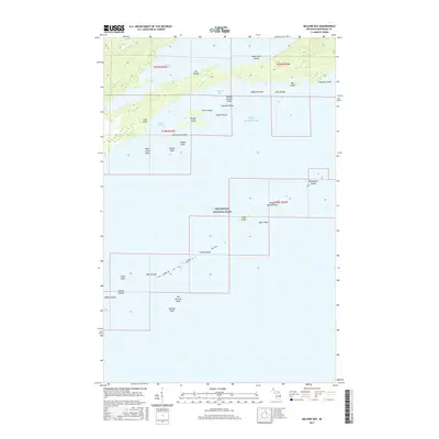
2017 Map of Malone Bay
USGS Topo · Published 2017About this map
Isle Royale National Park encompasses this maritime landscape of the Keweenaw Peninsula's north shore, where the archipelago breaks into a complex network of reefs and sheltered harbors. The topography is dominated by the narrow stretch of land separating the expansive Lake Superior from the interior Siskiwit Lake, connected by the short drainage of Siskiwit Falls. This aquatic orientation is reflected in the numerous named hazards and havens, such as Middle Ground Reef and the protected waters of Malone Bay.
Find a feature on this map
37 named features on this map. Tap any name to fly to it.
Don’t see what you’re looking for? This feature index may not catch every label — zoom into the map to look around manually.
Map Details
Editions of this 2017 Malone Bay Map
This is the sole edition of this map. No revisions or reprints were ever made.
Other maps of this area

1958 · Hancock
USGS Topo · 1:250,000

1959 · Fort William
USGS Topo · 1:250,000

1960 · Hancock
USGS Topo · 1:250,000

1961 · Hancock
USGS Topo · 1:250,000

1966 · Hancock
USGS Topo · 1:250,000

1968 · Fort William
USGS Topo · 1:250,000

1985 · Todd Harbor
USGS Topo · 1:100,000

1985 · Siskiwit Bay
USGS Topo · 1:100,000
1985 · Lake Richie
USGS Topo · 1:24,000
1985 · Todd Harbor
USGS Topo · 1:24,000