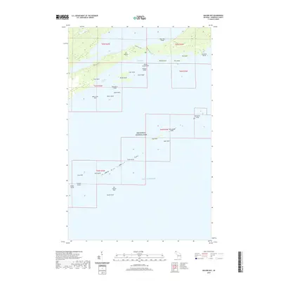
2019 Map of Malone Bay
USGS Topo · Published 2019About this map
Isle Royale National Park dominates this maritime landscape along the northern reaches of Lake Superior, where the interplay of water and rock defines the southern shoreline of the island. Large inland bodies of water like Siskiwit Lake are separated from Malone Bay by narrow ridges, with Siskiwit Falls marking the short descent to the lake shore. The Ishpeming Trail provides one of the few overland routes through the interior, winding past high ground and coastal inlets.
Find a feature on this map
39 named features on this map. Tap any name to fly to it.
Don’t see what you’re looking for? This feature index may not catch every label — zoom into the map to look around manually.
Map Details
Editions of this 2019 Malone Bay Map
This is the sole edition of this map. No revisions or reprints were ever made.
Other maps of this area

1958 · Hancock
USGS Topo · 1:250,000

1959 · Fort William
USGS Topo · 1:250,000

1960 · Hancock
USGS Topo · 1:250,000

1961 · Hancock
USGS Topo · 1:250,000

1966 · Hancock
USGS Topo · 1:250,000

1968 · Fort William
USGS Topo · 1:250,000

1985 · Todd Harbor
USGS Topo · 1:100,000

1985 · Siskiwit Bay
USGS Topo · 1:100,000
1985 · Lake Richie
USGS Topo · 1:24,000
1985 · Todd Harbor
USGS Topo · 1:24,000