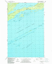
1985 Map of Malone Bay
USGS Topo · Published 1986About this map
Isle Royale National Park is defined by its complex archipelago of islands and reefs along the northern reaches of Lake Superior in the mid-1980s. The south-central coastline of the island features the deep waters of Siskiwit Bay, protected by a chain of smaller landmasses including Malone Island, Wright Island, and the distant Menagerie Island, where the Isle Royale Lighthouse stands as a sentinel. The map reveals the intricate aquatic geography of the region, detailing numerous hazardous shoals like Glenlyon Shoal and Butterfield Shoal, as well as named reefs such as Harlem Reef and San Antonio Reef. On the main island, the Malone Bay Campground and a nearby Ranger Station mark the intersections of human activity and wilderness near the mouth of the Siskiwit R. A single Trail follows the northern ridge above Siskiwit Lake, suggesting the isolation and maritime character of this Lake Superior preserve.
Find a feature on this map
48 named features on this map. Tap any name to fly to it.
Don’t see what you’re looking for? This feature index may not catch every label — zoom into the map to look around manually.
Map Details
Editions of this 1985 Malone Bay Map
This is the sole edition of this map. No revisions or reprints were ever made.
Other maps of this area

1958 · Hancock
USGS Topo · 1:250,000

1959 · Fort William
USGS Topo · 1:250,000

1960 · Hancock
USGS Topo · 1:250,000

1961 · Hancock
USGS Topo · 1:250,000

1966 · Hancock
USGS Topo · 1:250,000

1968 · Fort William
USGS Topo · 1:250,000

1985 · Todd Harbor
USGS Topo · 1:100,000

1985 · Siskiwit Bay
USGS Topo · 1:100,000
1985 · Lake Richie
USGS Topo · 1:24,000
1985 · Todd Harbor
USGS Topo · 1:24,000