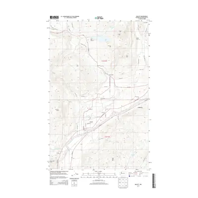
2014 Map of Malott
USGS Topo · Published 2014About this map
The Okanogan River meanders through this landscape in Okanogan County, serving as a primary geographic anchor for the settlements of Malott and Chillowist. This 2014 survey reveals a transition from the river valley's agricultural and residential development to the upland terrain of Soap Lake Mtn and Timerick Mtn. To the west, the Chillowist Cem and the prominent Chillowist Butte overlook the creek that shares their name, reflecting the local importance of this historic community site. Recreation and land use are centered around Leader Lake and its accompanying Leader Lake Campground, nestled between Leader Mtn and Fox Mtn. The map also details complex local drainage patterns through features like Dry Coulee, Spring Coulee, and Tallant Cr, illustrating the rugged topography that defines the eastern edge of the Cascade foothills.
Find a feature on this map
53 named features on this map. Tap any name to fly to it.
Don’t see what you’re looking for? This feature index may not catch every label — zoom into the map to look around manually.
Map Details
Editions of this 2014 Malott Map
This is the sole edition of this map. No revisions or reprints were ever made.
Other maps of this area

1905 · Okanogan
USGS Topo · 1:125,000

1954 · Okanogan
USGS Topo · 1:250,000

1956 · Loup Loup
USGS Topo · 1:62,500

1957 · Okanogan
USGS Topo · 1:62,500

1957 · Bridgeport
USGS Topo · 1:62,500

1957 · Brewster
USGS Topo · 1:62,500

1958 · Okanogan
USGS Topo · 1:250,000

1980 · Okanogan
USGS Topo · 1:24,000
1980 · Omak
USGS Topo · 1:24,000
1980 · White Lakes
USGS Topo · 1:24,000