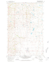
1980 Map of White Lakes
USGS Topo · Published 1981About this map
Scattered highland basins and rugged coulees define this portion of the Okanogan country, where water sources like White Lakes and McDonald Lake served as vital anchors for ranching and movement. The terrain is marked by a network of paths including a Jeep Trail that threads through the high plateaus between Salt Hill and the wide expanse of Timentwa Flats. These labels reflect a landscape of seasonal use and difficult access, characteristic of the region's semi-arid grazing lands before more modern development.
Find a feature on this map
24 named features on this map. Tap any name to fly to it.
Don’t see what you’re looking for? This feature index may not catch every label — zoom into the map to look around manually.
Map Details
Editions of this 1980 White Lakes Map
2 editions found
Other maps of this area

1905 · Okanogan
USGS Topo · 1:125,000

1950 · Boot Mtn
USGS Topo · 1:62,500

1953 · Omak Lake
USGS Topo · 1:62,500

1954 · Okanogan
USGS Topo · 1:250,000

1957 · Okanogan
USGS Topo · 1:62,500

1957 · Bridgeport
USGS Topo · 1:62,500

1958 · Okanogan
USGS Topo · 1:250,000

1980 · Okanogan
USGS Topo · 1:24,000
1980 · Bridgeport Point
USGS Topo · 1:24,000
1980 · Joe Lake
USGS Topo · 1:24,000