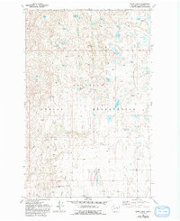
1980 Map of White Lakes
USGS Topo · Published 1993About this map
Colville Indian Reservation land dominates this high-plateau landscape, where water and topography dictate the pattern of human use. The terrain is a complex assembly of small, high-elevation water bodies like Hauan Lake, McDonald Lake, and White Lakes, many of which appear to be perched among glacial depressions. Movement across this landscape in the early 1980s was primarily limited to primitive tracks, noted on the map as 4wd routes, which navigate around major geological features like Salt Hill and the descent into Dan Canyon. The sparse infrastructure is highlighted by isolated industrial markers such as a Borrow Pit and the eastern edge of Tumeriwa Flats. This survey reveals a region where traditional land boundaries coexist with a topography of springs and lakes that likely served as critical landmarks for local travel and resource management.
Find a feature on this map
22 named features on this map. Tap any name to fly to it.
Don’t see what you’re looking for? This feature index may not catch every label — zoom into the map to look around manually.
Map Details
Editions of this 1980 White Lakes Map
2 editions found
Other maps of this area

1905 · Okanogan
USGS Topo · 1:125,000

1950 · Boot Mtn
USGS Topo · 1:62,500

1953 · Omak Lake
USGS Topo · 1:62,500

1954 · Okanogan
USGS Topo · 1:250,000

1957 · Okanogan
USGS Topo · 1:62,500

1957 · Bridgeport
USGS Topo · 1:62,500

1958 · Okanogan
USGS Topo · 1:250,000

1980 · Okanogan
USGS Topo · 1:24,000
1980 · Bridgeport Point
USGS Topo · 1:24,000
1980 · Joe Lake
USGS Topo · 1:24,000