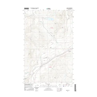
2017 Map of Malott
USGS Topo · Published 2017About this map
The Okanogan River carves a central path through this terrain, anchoring the small settlement of Malott along its western bank. The landscape transitions from the river valley to prominent peaks such as Leader Mtn and Chillowist Butte, revealing a complex network of coulees and flats including Spring Coulee and Tarheel Flat. For genealogists and local historians, the Chillowist Cem and the settlement of Chillowist serve as important touchpoints for family research in this part of Okanogan County.
Find a feature on this map
53 named features on this map. Tap any name to fly to it.
Don’t see what you’re looking for? This feature index may not catch every label — zoom into the map to look around manually.
Map Details
Editions of this 2017 Malott Map
This is the sole edition of this map. No revisions or reprints were ever made.
Other maps of this area

1905 · Okanogan
USGS Topo · 1:125,000

1954 · Okanogan
USGS Topo · 1:250,000

1956 · Loup Loup
USGS Topo · 1:62,500

1957 · Okanogan
USGS Topo · 1:62,500

1957 · Bridgeport
USGS Topo · 1:62,500

1957 · Brewster
USGS Topo · 1:62,500

1958 · Okanogan
USGS Topo · 1:250,000

1980 · Okanogan
USGS Topo · 1:24,000
1980 · Omak
USGS Topo · 1:24,000
1980 · White Lakes
USGS Topo · 1:24,000