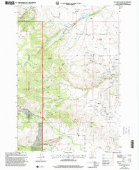
1997 Map of Maltbys Mound
USGS Topo · Published 2001About this map
Mining operations and timber harvesting define the late-twentieth-century landscape of this Madison County region, particularly along the eastern slopes of the Beaverhead National Forest. The map documents a complex history of extraction, from traditional shafts like the Revenue Mine and Galena Mine to modern industrial footprints such as the Open Pit Norwegian Mine. The terrain is characterized by high peaks including Sugarloaf Mountain and Wallace Peak, which feed a network of waterways including Norwegian Creek and Canadian Creek. Evidence of early settlement and industry is visible at Sterling and the Hagler Sawmill, while the Washington Bar Placer Mine near Washington Creek points to the area's gold-seeking heritage. The density of mine shafts, adits, and tailings throughout Pony Gulch and the surrounding hills provides a detailed record of the intensive mineral exploration that has shaped this part of Montana.
Find a feature on this map
41 named features on this map. Tap any name to fly to it.
Don’t see what you’re looking for? This feature index may not catch every label — zoom into the map to look around manually.
Map Details
Editions of this 1997 Maltbys Mound Map
This is the sole edition of this map. No revisions or reprints were ever made.
Other maps of this area

1888 · Three Forks
USGS Topo · 1:250,000

1894 · Three Forks
USGS Topo · 1:250,000

1895 · Three Forks
USGS Topo · 1:250,000

1947 · Bozeman
USGS Topo · 1:250,000

1948 · Bozeman
USGS Topo · 1:250,000

1949 · Ennis
USGS Topo · 1:62,500

1949 · Norris
USGS Topo · 1:62,500

1950 · Harrison
USGS Topo · 1:62,500

1950 · Virginia City
USGS Topo · 1:62,500

1951 · Norris
USGS Topo · 1:62,500