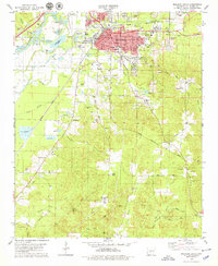
1978 Map of Malvern South
USGS Topo · Published 1979About this map
Industrial and community activity defines Malvern in the late 1970s, where the landscape is shaped by the extraction of local resources. Extensive Claypits, Gravel Pits, and Kilns surround the town, particularly near Perla, reflecting a long history of brick and mineral production. The Missouri Pacific and Pacific And Rock Island railroads provide the backbone for this economy, tracing routes through the river bottomlands.
Find a feature on this map
59 named features on this map. Tap any name to fly to it.
Don’t see what you’re looking for? This feature index may not catch every label — zoom into the map to look around manually.
Map Details
Editions of this 1978 Malvern South Map
This is the sole edition of this map. No revisions or reprints were ever made.
Other maps of this area

1948 · Malvern
USGS Topo · 1:62,500

1949 · Malvern
USGS Topo · 1:62,500

1955 · Little Rock
USGS Topo · 1:250,000

1956 · Little Rock
USGS Topo · 1:250,000

1960 · Little Rock
USGS Topo · 1:250,000

1963 · Traskwood
USGS Topo · 1:24,000

1964 · Poyen
USGS Topo · 1:24,000

1964 · Little Rock
USGS Topo · 1:250,000

1964 · Donaldson
USGS Topo · 1:24,000

1965 · Round Hill
USGS Topo · 1:24,000