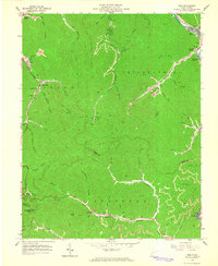
1963 Map of Man
USGS Topo · Published 1965About this map
The Guyandotte River flows through the northeast corner of this map, anchoring the town of Man and the residential area of Hensley Heights during the early 1960s. This region of the West Virginia coalfields is defined by a dense network of industrial activity, where numerous mines, mine dumps, and tipples are tucked into narrow hollows along Island Creek and Rockhouse Creek. The rail-dependent economy is evident in the presence of the Chesapeake and Ohio railroad, which services small coal settlements like Stirrat, Sarah Ann, and Superior Bottom. Family history is deeply rooted in the terrain, with several small burial grounds such as Hatfield Cem and Ellis Cem situated on the hillsides. The southern portion of the quadrangle shows the boundary between Logan Co and Mingo Co, marked by prominent landmarks like Horsepen Mtn and the Mingo Lookout Tower.
Find a feature on this map
65 named features on this map. Tap any name to fly to it.
Don’t see what you’re looking for? This feature index may not catch every label — zoom into the map to look around manually.
Map Details
Editions of this 1963 Man Map
3 editions found
Other maps of this area

1887 · Warfield
USGS Topo · 1:125,000

1891 · Oceana
USGS Topo · 1:125,000

1891 · Warfield
USGS Topo · 1:125,000

1893 · Oceana
USGS Topo · 1:125,000

1898 · Oceana
USGS Topo · 1:125,000

1909 · Matewan
USGS Topo · 1:48,000

1909 · Gilbert
USGS Topo · 1:48,000

1910 · Holden
USGS Topo · 1:48,000

1912 · Gilbert
USGS Topo · 1:62,500

1912 · Holden
USGS Topo · 1:62,500