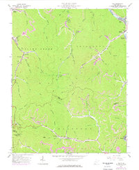
1963 Map of Man
USGS Topo · Published 1977About this map
The Guyandotte River flows through the northeast corner of this Logan County landscape, where the town of Man serves as a hub for the region's river and rail activity. The Chesapeake and Ohio railroad lines parallel the water, connecting coal-rich valleys. This mid-century topography reveals a landscape dominated by industrial infrastructure, including numerous instances of Mine and Tipple sites, especially along Rockhouse Creek and Island Creek. Settlements such as Superior Bottom, Sarah Ann, and Crystal Block are closely tied to these operations.
Find a feature on this map
69 named features on this map. Tap any name to fly to it.
Don’t see what you’re looking for? This feature index may not catch every label — zoom into the map to look around manually.
Map Details
Editions of this 1963 Man Map
3 editions found
Other maps of this area

1887 · Warfield
USGS Topo · 1:125,000

1891 · Oceana
USGS Topo · 1:125,000

1891 · Warfield
USGS Topo · 1:125,000

1893 · Oceana
USGS Topo · 1:125,000

1898 · Oceana
USGS Topo · 1:125,000

1909 · Matewan
USGS Topo · 1:48,000

1909 · Gilbert
USGS Topo · 1:48,000

1910 · Holden
USGS Topo · 1:48,000

1912 · Gilbert
USGS Topo · 1:62,500

1912 · Holden
USGS Topo · 1:62,500