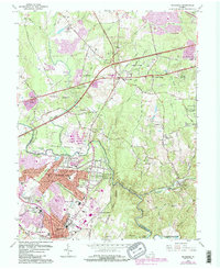
1966 Map of Manassas
USGS Topo · Published 1984About this map
Manassas and the nearby communities of Manassas Park and Yorkshire appear in a period of significant suburban expansion, with purple photorevised updates highlighting the growth of residential subdivisions like Loch Lomond and Point of Woods. The Southern Railway remains a primary corridor, passing through the heart of the area near the Courthouse and the local Quarry. Educational and civic development is evident through the placement of Osbourn Park High Sch and Prince William Hospital.
Find a feature on this map
96 named features on this map. Tap any name to fly to it.
Don’t see what you’re looking for? This feature index may not catch every label — zoom into the map to look around manually.
Map Details
Editions of this 1966 Manassas Map
4 editions found
Other maps of this area

1890 · Mt. Vernon
USGS Topo · 1:125,000

1891 · Mt. Vernon
USGS Topo · 1:125,000

1894 · Warrenton
USGS Topo · 1:125,000

1894 · Mt. Vernon
USGS Topo · 1:125,000

1897 · Mt. Vernon
USGS Topo · 1:125,000

1915 · Fairfax
USGS Topo · 1:62,500

1927 · Quantico
USGS Topo · 1:62,500

1933 · Middleburg
USGS Topo · 1:62,500

1940 · Quantico
USGS Topo · 1:62,500

1943 · Quantico
USGS Topo · 1:62,500