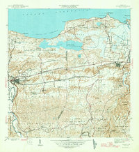
1946 Map of Manati
USGS Topo · Published 1946About this map
Agricultural colonies and sugar production define the inland landscape of Manatí during the mid-1940s. The settlement pattern is dominated by numerous colonias, such as Colonia Felix Cordova Davila and Colonia Coto Norte, which illustrate the intensive land use of the era. To the north, the coastal geography is marked by the expansive Laguna Tortuguero and the fishing village of Puerto Nuevo, sheltered by the rocky outcrops of Pta Puerto Nuevo.
Find a feature on this map
70 named features on this map. Tap any name to fly to it.
Don’t see what you’re looking for? This feature index may not catch every label — zoom into the map to look around manually.
Map Details
Editions of this 1946 Manati Map
3 editions found
Other maps of this area

1940 · Vega Alta
USGS Topo · 1:30,000

1942 · Manati
USGS Topo · 1:30,000

1942 · Barceloneta
USGS Topo · 1:30,000

1946 · Corozal
USGS Topo · 1:30,000

1946 · Barceloneta
USGS Topo · 1:30,000

1946 · Ciales
USGS Topo · 1:30,000

1946 · Florida
USGS Topo · 1:30,000

1946 · Vega Alta
USGS Topo · 1:30,000

1946 · Manati
USGS Topo · 1:30,000

1947 · Corozal NO
USGS Topo · 1:10,000