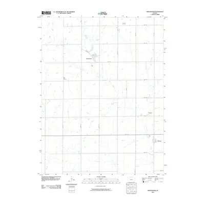
2009 Map of Manchester
USGS Topo · Published 2009About this map
Manchester and Talmage anchor this Dickinson County landscape, which is defined by the regular grid of the Public Land Survey System and the meandering paths of Mud Creek and Buckeye Creek. The area's rural heritage is preserved in several dedicated burial grounds, including Keystone Cemetery in the north and White Cloud Cemetery to the west. This 2009 survey illustrates how the original township structure persists, with modern thoroughfares such as Eden Rd and Fair Rd following section lines that have governed local travel for over a century. The layout of the small town sites compared to the surrounding farm tracts reveals a settlement pattern typical of the central plains, where small agricultural hubs served a dispersed community of growers. Near the eastern edge, Prairiedale Cemetery remains a quiet landmark within this expansive grid of section-line roads and seasonal drainage ways.
Find a feature on this map
24 named features on this map. Tap any name to fly to it.
Don’t see what you’re looking for? This feature index may not catch every label — zoom into the map to look around manually.
Map Details
Editions of this 2009 Manchester Map
This is the sole edition of this map. No revisions or reprints were ever made.
Other maps of this area

1889 · Abilene
USGS Topo · 1:125,000

1891 · Clay Center
USGS Topo · 1:125,000

1894 · Abilene
USGS Topo · 1:125,000

1955 · Niles
USGS Topo · 1:24,000

1955 · Manhattan
USGS Topo · 1:250,000

1955 · Hutchinson
USGS Topo · 1:250,000

1956 · Manhattan
USGS Topo · 1:250,000

1957 · Manhattan
USGS Topo · 1:250,000

1959 · Hutchinson
USGS Topo · 1:250,000
1963 · Solomon
USGS Topo · 1:24,000