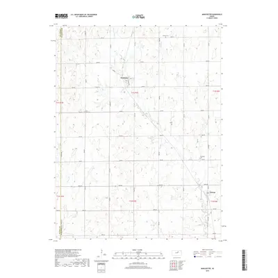
2018 Map of Manchester
USGS Topo · Published 2018About this map
The agrarian landscape of the Kansas prairie unfolds across this detailed survey of northern Dickinson County. Small rural centers such as Manchester and Talmage anchor a network of section-line roads and family-owned parcels, highlighting the persistent grid system of the Great Plains. The hydrology of the region is defined by the winding paths of Mud Creek and Buckeye Creek, which cut through the undulating terrain. Genealogists and local historians can locate several historic burial grounds, including Keystone Cemetery in the northeast and White Cloud Cemetery further west. The county line separating Ottawa County and Dickinson County runs along the western edge, near where Solomon Road follows the natural contours of the valley. This map provides a clear view of the modern road infrastructure, from 3600 Avenue down to 2800 Avenue, capturing the transition of these small farming communities into the early 21st century.
Find a feature on this map
38 named features on this map. Tap any name to fly to it.
Don’t see what you’re looking for? This feature index may not catch every label — zoom into the map to look around manually.
Map Details
Editions of this 2018 Manchester Map
This is the sole edition of this map. No revisions or reprints were ever made.
Other maps of this area

1889 · Abilene
USGS Topo · 1:125,000

1891 · Clay Center
USGS Topo · 1:125,000

1894 · Abilene
USGS Topo · 1:125,000

1955 · Niles
USGS Topo · 1:24,000

1955 · Manhattan
USGS Topo · 1:250,000

1955 · Hutchinson
USGS Topo · 1:250,000

1956 · Manhattan
USGS Topo · 1:250,000

1957 · Manhattan
USGS Topo · 1:250,000

1959 · Hutchinson
USGS Topo · 1:250,000
1963 · Solomon
USGS Topo · 1:24,000