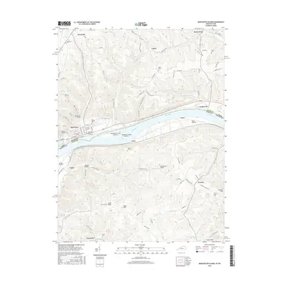
2016 Map of Manchester Islands
USGS Topo · Published 2016About this map
Manchester stands as a focal point along the northern bank of the Ohio River, where the state boundary between Ohio and Kentucky follows the river's path. This survey detail highlights the navigational and geographical importance of Manchester Island Number 1 and Manchester Island Number 2, which split the river's flow near the town center. The surrounding landscape of Adams County and Lewis County is deeply dissected by drainages like Island Creek and Crooked Cr, creating a series of hollows and ridges such as Williamson Hollow and Chalk Ridge. Numerous small burial sites, including the Odd Fellows Cem and Manchester Second Street Cem, are scattered throughout the hills, reflecting generations of family settlement. Smaller communities like Bentonville to the north and Wrightsville to the east are connected by a network of rural routes like Gift Ridge Rd, while the southern Kentucky side remains dominated by agricultural terrain around Trinity and Covedale.
Find a feature on this map
89 named features on this map. Tap any name to fly to it.
Don’t see what you’re looking for? This feature index may not catch every label — zoom into the map to look around manually.
Map Details
Editions of this 2016 Manchester Islands Map
This is the sole edition of this map. No revisions or reprints were ever made.
Other maps of this area

1916 · Peebles
USGS Topo · 1:62,500

1918 · Peebles
USGS Topo · 1:62,500

1918 · Seaman
USGS Topo · 1:62,500

1919 · Vanceburg
USGS Topo · 1:62,500

1929 · Springdale
USGS Topo · 1:48,000

1935 · Springdale
USGS Topo · 1:62,500

1949 · Vanceburg
USGS Topo · 1:62,500

1949 · Concord
USGS Topo · 1:24,000

1949 · Charters
USGS Topo · 1:24,000

1950 · Charters
USGS Topo · 1:24,000