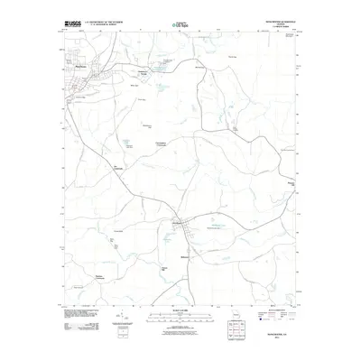
2011 Map of Manchester
USGS Topo · Published 2011About this map
Manchester serves as the primary urban center in this Georgia landscape, situated north of a series of ridges and mountain gaps. The town's layout is centered around the Manchester Post Office and E Main St, with a network of local roads branching out into the surrounding rural communities. These outlying areas are defined by historic intersections and small settlements such as Chalybeate Springs, Tax Crossroads, and Cunningham Crossroads.
Find a feature on this map
66 named features on this map. Tap any name to fly to it.
Don’t see what you’re looking for? This feature index may not catch every label — zoom into the map to look around manually.
Map Details
Editions of this 2011 Manchester Map
This is the sole edition of this map. No revisions or reprints were ever made.
Other maps of this area

1907 · Talbotton
USGS Topo · 1:125,000

1934 · Warm Springs
USGS Topo · 1:62,500

1935 · Thomaston
USGS Topo · 1:48,000

1936 · Warm Springs
USGS Topo · 1:62,500

1939 · Thomaston
USGS Topo · 1:62,500

1950 · Talbotton
USGS Topo · 1:24,000

1950 · Waverly Hall
USGS Topo · 1:24,000

1950 · Talbotton
USGS Topo · 1:62,500

1955 · Talbotton
USGS Topo · 1:24,000
1955 · Waverly Hall
USGS Topo · 1:24,000