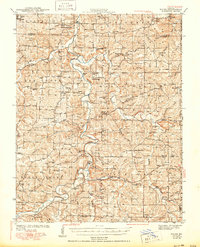
1943 Map of Manes
USGS Topo · Published 1950About this map
The Gasconade River winds through this terrain on the border of Laclede and Wright counties, defining a landscape of hollows and ridges during the early 1940s. The settlement of Manes serves as a central hub, surrounded by a dense network of country schools and churches that speak to the rural social structure of the era. Educational landmarks like Victory Sch and Cheerful Hill Sch are scattered throughout the hills, while spiritual centers such as Evening Shade Ch and Claxton Ch anchor the various communities. Along the river and its tributaries, evidence of local industry appears at Grimes Mill and Latham Mill, illustrating the importance of water power for the area's residents. Much of the eastern portion of the sheet is comprised of the Mark Twain National Forest, showing the division between agricultural clearings and managed timberland during this period of Missouri's history.
Find a feature on this map
83 named features on this map. Tap any name to fly to it.
Don’t see what you’re looking for? This feature index may not catch every label — zoom into the map to look around manually.
Map Details
Editions of this 1943 Manes Map
3 editions found
Other maps of this area

1931 · Manes
USGS Topo · 1:48,000

1941 · Big Piney
USGS Topo · 1:62,500

1941 · Manes
USGS Topo · 1:62,500

1941 · Lebanon
USGS Topo · 1:62,500

1941 · Bado
USGS Topo · 1:62,500

1943 · Lebanon
USGS Topo · 1:62,500

1943 · Big Piney
USGS Topo · 1:62,500

1943 · Manes
USGS Topo · 1:62,500

1943 · Drynob
USGS Topo · 1:62,500

1943 · Bado
USGS Topo · 1:62,500