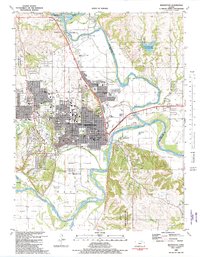
1982 Map of Manhattan
USGS Topo · Published 1982About this map
Kansas State University serves as a central anchor for the landscape of this 1982 survey, surrounded by the established neighborhoods and institutional buildings of Manhattan. The city's mid-century expansion is evidenced by several schools, including Seven Dolors Sch and Luckey High Sch, alongside critical infrastructure like the Memorial Hospital and the sprawling Waterworks facility. The confluence of the Big Blue River and the Kansas River defines the local geography, creating fertile lowlands such as Ashland Bottoms and Moehlman Bottoms.
Find a feature on this map
67 named features on this map. Tap any name to fly to it.
Don’t see what you’re looking for? This feature index may not catch every label — zoom into the map to look around manually.
Map Details
Editions of this 1982 Manhattan Map
This is the sole edition of this map. No revisions or reprints were ever made.
Other maps of this area

1886 · Junction City
USGS Topo · 1:125,000

1889 · Wamego
USGS Topo · 1:125,000

1889 · Junction City
USGS Topo · 1:125,000

1894 · Junction City
USGS Topo · 1:125,000

1894 · Wamego
USGS Topo · 1:125,000

1947 · Manhattan
USGS Topo · 1:62,500

1950 · Keats
USGS Topo · 1:24,000

1950 · Manhattan
USGS Topo · 1:24,000

1951 · Swede Creek
USGS Topo · 1:24,000

1951 · Ogden
USGS Topo · 1:24,000