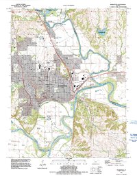
1991 Map of Manhattan
USGS Topo · Published 1995About this map
Manhattan sits at the significant confluence of the Big Blue River and the Kansas River, a landscape defined by both collegiate expansion and riverine topography. The expansive campus of Kansas State University dominates the western portion of the city, complete with its Stadium and proximity to residential corridors like College Heights Rd and Bluemont Ave. The map captures the city's relationship with its waterways, showing the protected areas of Tuttle Creek State Park (River Pond Area) and the Rocky Ford State Fishing Area to the north. South of the city center, the Union Pacific rail line skirts the edge of Moehlman Bottoms and Hunters Island, illustrating the industrial and transport infrastructure that supported this regional hub. From the high ground at Stagg Hill to the river valleys, the survey provides a clear view of the city's late 20th-century footprint.
Find a feature on this map
50 named features on this map. Tap any name to fly to it.
Don’t see what you’re looking for? This feature index may not catch every label — zoom into the map to look around manually.
Map Details
Editions of this 1991 Manhattan Map
This is the sole edition of this map. No revisions or reprints were ever made.
Other maps of this area

1886 · Junction City
USGS Topo · 1:125,000

1889 · Wamego
USGS Topo · 1:125,000

1889 · Junction City
USGS Topo · 1:125,000

1894 · Junction City
USGS Topo · 1:125,000

1894 · Wamego
USGS Topo · 1:125,000

1947 · Manhattan
USGS Topo · 1:62,500

1950 · Keats
USGS Topo · 1:24,000

1950 · Manhattan
USGS Topo · 1:24,000

1951 · Swede Creek
USGS Topo · 1:24,000

1951 · Ogden
USGS Topo · 1:24,000