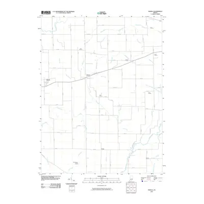
2010 Map of Manilla
USGS Topo · Published 2010About this map
Manilla and the surrounding agricultural lands of Rush County appear here in a transition between traditional rural life and modern development. The landscape is defined by an intricate network of waterways and drainage ditches essential for local farming, including the Flatrock River, Little Blue River, and Conns Creek. Historically significant family names are preserved throughout the area in the form of numerous small burial grounds such as Sells Cemetery, Bebout Cemetery, and the uniquely named Radar-Bowman-Worland Cemetery. The small settlements of Homer and Gowdy serve as focal points for this region, connected by a rigid grid of county roads. These thoroughfares, such as W Base Rd and S Angling Rd, follow the natural contours and established property lines, reflecting the organized settlement patterns of this Indiana heartland.
Find a feature on this map
61 named features on this map. Tap any name to fly to it.
Don’t see what you’re looking for? This feature index may not catch every label — zoom into the map to look around manually.
Map Details
Editions of this 2010 Manilla Map
This is the sole edition of this map. No revisions or reprints were ever made.
Other maps of this area

1942 · Columbus
USGS Topo · 1:125,000

1953 · Cincinnati
USGS Topo · 1:250,000

1956 · Morristown
USGS Topo · 1:24,000

1956 · Waldron
USGS Topo · 1:24,000

1956 · Rays Crossing
USGS Topo · 1:24,000

1957 · Cincinnati
USGS Topo · 1:250,000

1959 · Milroy
USGS Topo · 1:24,000

1959 · Rushville
USGS Topo · 1:24,000
1959 · Adams
USGS Topo · 1:24,000

1959 · Mays
USGS Topo · 1:24,000