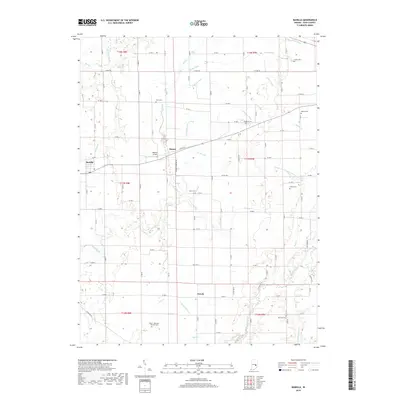
2019 Map of Manilla
USGS Topo · Published 2019About this map
Manilla and the surrounding agricultural townships of Rush County are defined by a complex network of named drainage ditches and creeks that support this fertile corner of Indiana. The landscape is punctuated by several small communities, including Homer and Gowdy, which serve as anchors for the local rural economy. The mapping of the Flatrock River and Little Blue River in the western and southern reaches illustrates the natural watercourses that first drew settlers to the area.
Find a feature on this map
63 named features on this map. Tap any name to fly to it.
Don’t see what you’re looking for? This feature index may not catch every label — zoom into the map to look around manually.
Map Details
Editions of this 2019 Manilla Map
This is the sole edition of this map. No revisions or reprints were ever made.
Other maps of this area

1942 · Columbus
USGS Topo · 1:125,000

1953 · Cincinnati
USGS Topo · 1:250,000

1956 · Morristown
USGS Topo · 1:24,000

1956 · Waldron
USGS Topo · 1:24,000

1956 · Rays Crossing
USGS Topo · 1:24,000

1957 · Cincinnati
USGS Topo · 1:250,000

1959 · Milroy
USGS Topo · 1:24,000

1959 · Rushville
USGS Topo · 1:24,000
1959 · Adams
USGS Topo · 1:24,000

1959 · Mays
USGS Topo · 1:24,000