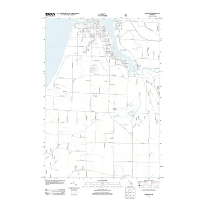
2012 Map of Manistee
USGS Topo · Published 2012About this map
Industrial enterprise and coastal geography define the shoreline of Lake Michigan south of the Manistee River. This 2012 survey illustrates the concentration of salt and chemical production along Manistee Lake, including the Morton Salt Company, Hardy Salt Company, and Martin Marietta Chemicals. These facilities, alongside the Manistee Drop Forge Corporation and Packaging Corporation of America, highlight the area's enduring reliance on heavy industry and waterfront access. To the south, the landscape transitions into recreation and residential spaces, featuring the Manistee National Golf and Resort and small inland waters like King Lake and Shingle Mill Lake. Genealogists will find interest in the documented burial grounds of Mount Carmel Cem, Trinity Cem, and Long Lake Cem, which serve the communities of Oak Hill, Filer City, and Stronach. The map also captures local landmarks such as the Century Boat Company and the winding course of the Little Manistee River as it meets the larger lake.
Find a feature on this map
89 named features on this map. Tap any name to fly to it.
Don’t see what you’re looking for? This feature index may not catch every label — zoom into the map to look around manually.
Map Details
Editions of this 2012 Manistee Map
This is the sole edition of this map. No revisions or reprints were ever made.
Other maps of this area

1931 · Manistee SE
USGS Topo · 1:31,680

1931 · Freesoil SW
USGS Topo · 1:31,680

1931 · Manistee SW
USGS Topo · 1:31,680

1954 · Manitowoc
USGS Topo · 1:250,000

1956 · Onekama
USGS Topo · 1:62,500

1956 · Bar Lake
USGS Topo · 1:62,500

1957 · Freesoil
USGS Topo · 1:62,500

1958 · Manitowoc
USGS Topo · 1:250,000

1958 · Manistee
USGS Topo · 1:62,500

1976 · Onekama SW
USGS Topo · 1:24,000