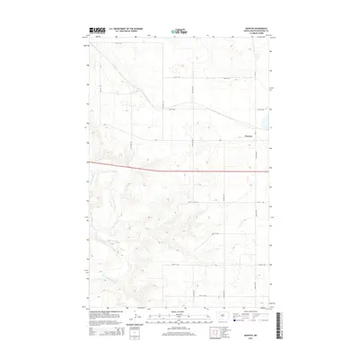
2014 Map of Manitou
USGS Topo · Published 2014About this map
White Earth River carves a deep valley through the western edge of this Mountrail County landscape, creating a stark contrast to the higher, pothole-dotted plains to the east. The settlement of Manitou occupies a central position on the upland plateau, served by a network of rural routes including Cr-3111 and Cr-2. This 2014 survey documents the area's agricultural character, defined by a strict section-line road grid—such as 64th St NW and 95th Ave NW—that persists despite the significant topographical relief created by the river's drainage basin. The map illustrates how local transportation and settlement patterns are dictated by the land's transition from flat prairie to the eroded breaks of the river valley.
Find a feature on this map
17 named features on this map. Tap any name to fly to it.
Don’t see what you’re looking for? This feature index may not catch every label — zoom into the map to look around manually.
Map Details
Editions of this 2014 Manitou Map
This is the sole edition of this map. No revisions or reprints were ever made.
Other maps of this area

1953 · Williston
USGS Topo · 1:250,000

1957 · Williston
USGS Topo · 1:250,000

1965 · Charlson NE
USGS Topo · 1:24,000

1969 · Ross NW
USGS Topo · 1:24,000

1969 · White Earth
USGS Topo · 1:24,000

1979 · Tioga SE
USGS Topo · 1:24,000

1981 · Robinson Lake
USGS Topo · 1:24,000

1981 · Ross
USGS Topo · 1:24,000

1981 · Manitou
USGS Topo · 1:24,000
1981 · Rat Lake
USGS Topo · 1:24,000