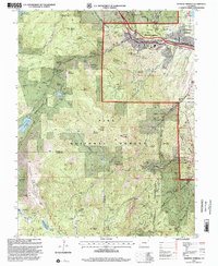
1994 Map of Manitou Springs
USGS Topo · Published 2001About this map
Manitou Springs serves as the gateway to the foothills in this 1990s revision, where the Manitou and Pikes Peak Railway begins its ascent toward the west. The landscape is defined by its dramatic relief and water management, visible through a series of high-altitude catchments like Ruxton Reservoir, Lake Moraine, and Mc Reynolds Reservoir. Outdoor recreation and historical tourism routes are well-established, including the celebrated Barr Trail and the Pikes Peak Toll Road, which navigate the steep slopes of Mount Manitou and Almagre Mountain. Significant public land boundaries are clearly marked, with the Pike National Forest encompassing much of the area and protected zones like the Hurricane Canyon Natural Area preserving the local ecology. Cultural landmarks such as Seven Falls and North Cheyenne Canyon Park further highlight the region's importance as a natural and recreational destination.
Find a feature on this map
102 named features on this map. Tap any name to fly to it.
Don’t see what you’re looking for? This feature index may not catch every label — zoom into the map to look around manually.
Map Details
Editions of this 1994 Manitou Springs Map
This is the sole edition of this map. No revisions or reprints were ever made.
Other maps of this area

1893 · Colorado Springs
USGS Topo · 1:125,000

1894 · Pikes Peak
USGS Topo · 1:125,000

1901 · Pikes Peak
USGS Topo · 1:125,000

1901 · Pikes Peak
USGS Topo · 1:62,500

1909 · Colorado Springs
USGS Topo · 1:125,000

1942 · Colorado Springs
USGS Topo · 1:125,000

1948 · Mount Big Chief
USGS Topo · 1:24,000

1948 · Manitou Springs
USGS Topo · 1:24,000

1948 · Colorado Springs
USGS Topo · 1:62,500

1948 · Pikeview
USGS Topo · 1:24,000