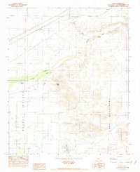
1982 Map of Manix
USGS Topo · Published 1982About this map
Mojave Valley terrain dominates this 1982 survey, where the episodic Mojave River carves a path through the arid San Bernardino desert. The map documents the specific locations of historic outposts like the Camp Cady (Site) and the Camp Cady Ranch, which were critical waypoints for early travelers through this corridor. To the east, the rising slopes of the Cady Mountains and Soldier Mtn overlook a landscape of washes and basins, including the ephemeral Troy Lake and Fourmile Waterhole. This provisional edition serves as a record of the region's sparse but essential water sources, including Cady Spring, and the navigational infrastructure of the era, such as the Vortac Facility and the rail line passing through Manix.
Find a feature on this map
16 named features on this map. Tap any name to fly to it.
Don’t see what you’re looking for? This feature index may not catch every label — zoom into the map to look around manually.
Map Details
Editions of this 1982 Manix Map
4 editions found
Other maps of this area

1933 · Avawatz Mountains
USGS Topo · 1:250,000

1947 · Trona
USGS Topo · 1:250,000

1948 · Trona
USGS Topo · 1:250,000

1948 · Alvord Mountain
USGS Topo · 1:62,500

1948 · Cave Mountain
USGS Topo · 1:62,500

1951 · Cave Mountain
USGS Topo · 1:62,500

1951 · Alvord Mountain
USGS Topo · 1:62,500

1953 · San Bernardino
USGS Topo · 1:250,000

1953 · Trona
USGS Topo · 1:250,000

1955 · Newberry
USGS Topo · 1:62,500