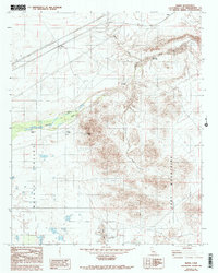
1982 Map of Manix
USGS Topo · Published 1993About this map
Camp Cady (Site) and the Camp Cady Ranch anchor this arid landscape where the ephemeral Mojave River winds through the high desert of the Mojave Valley. The map details a transition from the level floor of the valley to the sharp elevations of the Cady Mountains, marked by peaks like Soldier Mtn and The Knob.
Find a feature on this map
17 named features on this map. Tap any name to fly to it.
Don’t see what you’re looking for? This feature index may not catch every label — zoom into the map to look around manually.
Map Details
Editions of this 1982 Manix Map
4 editions found
Other maps of this area

1933 · Avawatz Mountains
USGS Topo · 1:250,000

1947 · Trona
USGS Topo · 1:250,000

1948 · Trona
USGS Topo · 1:250,000

1948 · Alvord Mountain
USGS Topo · 1:62,500

1948 · Cave Mountain
USGS Topo · 1:62,500

1951 · Cave Mountain
USGS Topo · 1:62,500

1951 · Alvord Mountain
USGS Topo · 1:62,500

1953 · San Bernardino
USGS Topo · 1:250,000

1953 · Trona
USGS Topo · 1:250,000

1955 · Newberry
USGS Topo · 1:62,500