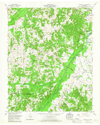
1965 Map of Manleyville
USGS Topo · Published 1967About this map
Manleyville serves as a central point in this mid-1960s landscape, where the agricultural uplands of Henry County meet the managed bottomlands of the Big Sandy River Dewatering Area. The terrain is defined by a dense network of cemeteries and small rural churches, such as Manleys Chapel Cem and Williams Grove Ch, which suggest established family lineages and deep-rooted community ties across the Pleasant Hill ridge.
Find a feature on this map
63 named features on this map. Tap any name to fly to it.
Don’t see what you’re looking for? This feature index may not catch every label — zoom into the map to look around manually.
Map Details
Editions of this 1965 Manleyville Map
2 editions found
Other maps of this area

1936 · Poplar Creek
USGS Topo · 1:24,000

1936 · Camden
USGS Topo · 1:24,000

1936 · Big Sandy
USGS Topo · 1:24,000

1936 · Mansfield
USGS Topo · 1:24,000

1936 · Vale
USGS Topo · 1:24,000

1936 · Bruceton
USGS Topo · 1:24,000

1936 · Manleyville
USGS Topo · 1:24,000

1936 · Paris
USGS Topo · 1:24,000

1936 · Springville
USGS Topo · 1:24,000

1938 · Springville
USGS Topo · 1:24,000