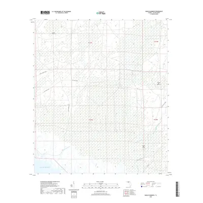
2018 Map of Manlin Hammock
USGS Topo · Published 2018About this map
Manlin Hammock and the surrounding marshy lowlands of Taylor County meet the Gulf of Mexico in this detailed survey of the Florida coastline. The landscape is defined by a network of drainage sloughs and creeks, including Steer Pen Slough and Smokehouse Cr, which carve through the dense wetlands. The interior is navigated primarily by long, straight tracks such as Rattlesnake Grade and Mossey Hammock Grade, reflecting the area's history of timber harvesting and land management. Near the mouth of the Fenholloway River, localized high points like Thomas Mill Hammock and Thomas Mill Island provide rare footing above the tide line. The presence of Old Club House Rd and Thomas Mill Run suggests a long-standing coastal economy centered on the river's resources. This 2018 survey provides a clear view of the tidewater hydrology and the traditional access routes used to navigate these coastal hammocks.
Find a feature on this map
20 named features on this map. Tap any name to fly to it.
Don’t see what you’re looking for? This feature index may not catch every label — zoom into the map to look around manually.
Map Details
Editions of this 2018 Manlin Hammock Map
This is the sole edition of this map. No revisions or reprints were ever made.
Other maps of this area

1952 · Secotan
USGS Topo · 1:24,000

1954 · Johnson Hammock
USGS Topo · 1:24,000

1954 · Hampton Springs
USGS Topo · 1:24,000

1954 · Secotan
USGS Topo · 1:24,000

1954 · Okefenokee Slough
USGS Topo · 1:24,000

1954 · Gainesville
USGS Topo · 1:250,000

1954 · Valdosta
USGS Topo · 1:250,000

1955 · Snipe Island
USGS Topo · 1:24,000

1955 · Nutall Rise
USGS Topo · 1:24,000

1955 · Rock Islands
USGS Topo · 1:24,000