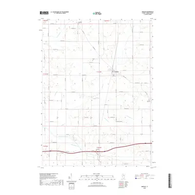
2018 Map of Manlius
USGS Topo · Published 2018About this map
Manlius serves as the central hub for this portion of Bureau County, surrounded by a complex network of agricultural drainage systems and rural cemeteries. The landscape is defined by the managed flow of water through features like Hasbrook Lateral Ditch, Devils Slough Ditch, and Smith Ditch, which redirect water toward the Green River and Hickory Cr. These engineered waterways reflect the region's intensive agricultural history, where the naturally wet prairie was systematically drained for cultivation. Local heritage is preserved in several small burial grounds, including the New Bedford Chapel Cem to the north and the Sand Hill Baptist Cem near Maple Grove Cr to the east. Roads such as Backbone Rd and Princeton Rd connect the village to the surrounding farmsteads, while the dense grid of county roads, including Co RD 2400 N and 1200 E St, provides access to the patchwork of fields that dominate the terrain.
Find a feature on this map
74 named features on this map. Tap any name to fly to it.
Don’t see what you’re looking for? This feature index may not catch every label — zoom into the map to look around manually.
Map Details
Editions of this 2018 Manlius Map
This is the sole edition of this map. No revisions or reprints were ever made.
Other maps of this area

1921 · Buda
USGS Topo · 1:62,500

1923 · Buda
USGS Topo · 1:62,500

1929 · Annawan
USGS Topo · 1:62,500

1932 · Prophetstown
USGS Topo · 1:48,000

1932 · Annawan
USGS Topo · 1:62,500

1936 · Prophetstown
USGS Topo · 1:62,500

1949 · Walnut
USGS Topo · 1:62,500

1958 · Aurora
USGS Topo · 1:250,000

1961 · Aurora
USGS Topo · 1:250,000
1982 · New Bedford
USGS Topo · 1:24,000