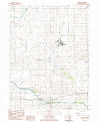
1983 Map of Manlius
USGS Topo · Published 1984About this map
Manlius serves as the central hub of this Bureau County landscape, where the Chicago and Northwestern rail line bisects the town's grid of streets like Maple Ave and Pine St. The surrounding terrain is heavily defined by a complex drainage network designed to manage the fertile prairie, including the Smith Ditch and several numbered channels such as Ditch No 4 and Ditch No 5. To the south, the historic Hennepin Canal and its associated Hasbrook Lateral mark a significant era of 19th-century water engineering, now preserved within the Hennepin Canal Parkway State Park. Local history is anchored by several family and community burial grounds, including Chapel Cem, Follett Cem, and Sand Hill Cem, providing vital reference points for genealogists. The transition from the alluvial flats of the Green River and Devils Slough to the upland rises like Sand Hill illustrates the topographic character of this agricultural heartland during the early 1980s.
Find a feature on this map
32 named features on this map. Tap any name to fly to it.
Don’t see what you’re looking for? This feature index may not catch every label — zoom into the map to look around manually.
Map Details
Editions of this 1983 Manlius Map
This is the sole edition of this map. No revisions or reprints were ever made.
Other maps of this area

1921 · Buda
USGS Topo · 1:62,500

1923 · Buda
USGS Topo · 1:62,500

1929 · Annawan
USGS Topo · 1:62,500

1932 · Prophetstown
USGS Topo · 1:48,000

1932 · Annawan
USGS Topo · 1:62,500

1936 · Prophetstown
USGS Topo · 1:62,500

1949 · Walnut
USGS Topo · 1:62,500

1958 · Aurora
USGS Topo · 1:250,000

1961 · Aurora
USGS Topo · 1:250,000
1982 · New Bedford
USGS Topo · 1:24,000