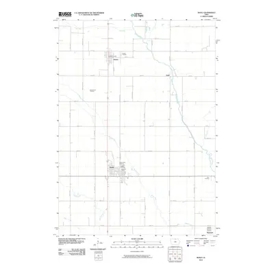
2010 Map of Manly
USGS Topo · Published 2010About this map
The agricultural landscape of Worth County centers on the town of Manly, which serves as a notable hub along the north-south transport corridor. The grid of country roads, including N Broadway St and Olive Ave, connects smaller settlements like Kensett and Plymouth across a terrain defined by the winding course of the Shell Rock River and its tributaries, such as Beaver Creek and Elk Creek. This 2010 survey highlights a significant concentration of local heritage sites, particularly in the density of rural burial grounds. Genealogists and local historians can trace family ties through the many named cemeteries, from the larger Manly Cemetery and Sacred Heart Cemetery to smaller or more specialized plots like Brystol Farm Cemetery, Wise Cemetery, and Bohemian Cemetery. Together, these features document the persistent structure of Iowa's farming communities and the centers of civic life like the Manly Post Office.
Find a feature on this map
41 named features on this map. Tap any name to fly to it.
Don’t see what you’re looking for? This feature index may not catch every label — zoom into the map to look around manually.
Map Details
Editions of this 2010 Manly Map
This is the sole edition of this map. No revisions or reprints were ever made.
Other maps of this area

1954 · Mason City
USGS Topo · 1:250,000

1957 · Mason City
USGS Topo · 1:250,000

1958 · Mason City
USGS Topo · 1:250,000

1959 · Mason City
USGS Topo · 1:24,000

1959 · Mason City
USGS Topo · 1:62,500

1959 · Nora Springs
USGS Topo · 1:24,000

1972 · Manly
USGS Topo · 1:24,000

1972 · Northwood
USGS Topo · 1:24,000

1972 · Fertile NE
USGS Topo · 1:24,000
1972 · Clear Lake East
USGS Topo · 1:24,000