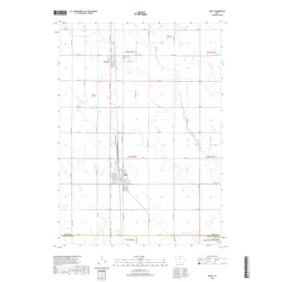
2018 Map of Manly
USGS Topo · Published 2018About this map
Manly serves as the central hub of this north-central Iowa landscape, where a precise grid of rural roads meets the junction of regional rail lines. The town's layout, defined by streets like W Main St and W North St, sits just north of the Worth Co Cerro Gordo Co line. This agricultural territory is etched by the meandering courses of the Shell Rock River and Beaver Cr, which break the regularity of the section lines. For family historians, the map is particularly detailed, pinpointing several small burial sites including the Overholt Family Plot and the Brystol Farm Cem. Further south, the settlement of Plymouth appears near the Bohemian Cem and Oakwood Cem, illustrating the settlement patterns of early farming communities in the region.
Find a feature on this map
43 named features on this map. Tap any name to fly to it.
Don’t see what you’re looking for? This feature index may not catch every label — zoom into the map to look around manually.
Map Details
Editions of this 2018 Manly Map
This is the sole edition of this map. No revisions or reprints were ever made.
Other maps of this area

1954 · Mason City
USGS Topo · 1:250,000

1957 · Mason City
USGS Topo · 1:250,000

1958 · Mason City
USGS Topo · 1:250,000

1959 · Mason City
USGS Topo · 1:24,000

1959 · Mason City
USGS Topo · 1:62,500

1959 · Nora Springs
USGS Topo · 1:24,000

1972 · Manly
USGS Topo · 1:24,000

1972 · Northwood
USGS Topo · 1:24,000

1972 · Fertile NE
USGS Topo · 1:24,000
1972 · Clear Lake East
USGS Topo · 1:24,000