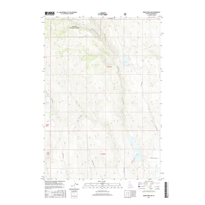
2017 Map of Mann Creek NW
USGS Topo · Published 2017About this map
Payette National Forest dominates the northern reaches of this Washington County landscape, where the high-elevation drainage of Fir Cr and Adams Cr flows southward into the Mann Cr valley. This 2017 survey details a region defined by its water management and forestry infrastructure, most notably marked by the Mann Creek Reservoir in the southeast and the smaller Fairchild Reservoir to its north. The transportation network reflects the rugged topography, with routes like Upper Mann Creek Rd and Monroe Cr Rd tracing the natural contours of the stream beds. These roads serve as vital links through the drainage basins of Jenkins Cr and Deer Cr, illustrating the modern management of these western public lands and their essential water resources.
Find a feature on this map
25 named features on this map. Tap any name to fly to it.
Don’t see what you’re looking for? This feature index may not catch every label — zoom into the map to look around manually.
Map Details
Editions of this 2017 Mann Creek NW Map
This is the sole edition of this map. No revisions or reprints were ever made.
Other maps of this area

1897 · Weiser
USGS Topo · 1:125,000

1915 · Pine
USGS Topo · 1:125,000

1952 · Olds Ferry
USGS Topo · 1:62,500

1952 · Olds Ferry SE
USGS Topo · 1:24,000

1953 · Mann Creek
USGS Topo · 1:62,500

1955 · Baker
USGS Topo · 1:250,000

1957 · Sturgill Peak
USGS Topo · 1:62,500

1957 · Mineral
USGS Topo · 1:62,500

1959 · Baker
USGS Topo · 1:250,000
1974 · Mann Creek SW
USGS Topo · 1:24,000