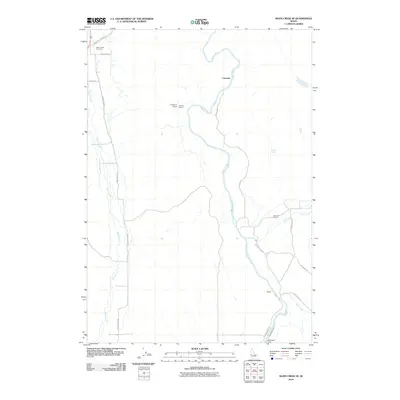
2010 Map of Mann Creek SE
USGS Topo · Published 2010About this map
Mann Creek and the Weiser River converge in this agricultural landscape of Washington County, Idaho, during the early 21st century. The map reveals a dispersed settlement pattern defined by rural school sites like Enterprise School, Catrock School, and Echo Dell School, which speak to the historic community structure of the valley. Significant water infrastructure is evident in the south, where the Galloway Dam manages the flow near the Weiser River Sunnyside Canal, supporting the irrigation needs of the surrounding fields.
Find a feature on this map
20 named features on this map. Tap any name to fly to it.
Don’t see what you’re looking for? This feature index may not catch every label — zoom into the map to look around manually.
Map Details
Editions of this 2010 Mann Creek SE Map
This is the sole edition of this map. No revisions or reprints were ever made.
Other maps of this area

1897 · Weiser
USGS Topo · 1:125,000

1951 · Weiser South
USGS Topo · 1:24,000

1952 · Weiser Cove
USGS Topo · 1:24,000

1953 · Mann Creek
USGS Topo · 1:62,500

1955 · Baker
USGS Topo · 1:250,000

1957 · Crane Creek Reservoir
USGS Topo · 1:62,500

1959 · Baker
USGS Topo · 1:250,000
1970 · Holland Gulch
USGS Topo · 1:24,000
1974 · Weiser South
USGS Topo · 1:24,000
1974 · Mann Creek SW
USGS Topo · 1:24,000