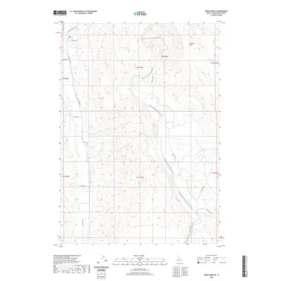
2020 Map of Mann Creek SE
USGS Topo · Published 2020About this map
The Weiser River cuts a prominent path through this Idaho landscape, flanked by the Weiser River National Recreation Trail which follows the river's eastern bank south toward the Sunnyside Canal. The settlement of Concrete sits along the river's bend, serving as a landmark in a terrain defined by drainage systems like Dead Man Gulch and Sandy Spring. To the west, the winding course of Mann Cr is paralleled by Mann Creek Rd, leading north toward the Mann Creek Cem.
Find a feature on this map
25 named features on this map. Tap any name to fly to it.
Don’t see what you’re looking for? This feature index may not catch every label — zoom into the map to look around manually.
Map Details
Editions of this 2020 Mann Creek SE Map
This is the sole edition of this map. No revisions or reprints were ever made.
Other maps of this area

1897 · Weiser
USGS Topo · 1:125,000

1951 · Weiser South
USGS Topo · 1:24,000

1952 · Weiser Cove
USGS Topo · 1:24,000

1953 · Mann Creek
USGS Topo · 1:62,500

1955 · Baker
USGS Topo · 1:250,000

1957 · Crane Creek Reservoir
USGS Topo · 1:62,500

1959 · Baker
USGS Topo · 1:250,000
1970 · Holland Gulch
USGS Topo · 1:24,000
1974 · Weiser South
USGS Topo · 1:24,000
1974 · Mann Creek SW
USGS Topo · 1:24,000