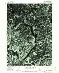
1974 Map of Mann Creek SW
USGS Topo · Published 1975About this map
Weiser anchors the southwestern edge of this orthophotomap, showing the transition from a gridded town layout into the surrounding agricultural and wild landscapes of Washington County. Taken from an aerial survey in the summer of 1974, the imagery captures the dense network of irrigation and field patterns concentrated along the lower reaches of Jenkins Creek. To the east, the terrain rises toward Sagebrush Hill, where the photographic detail reveals the intricate drainages and vegetation patterns of the Idaho foothills. The course of Mann Creek dominates the central valley, serving as a primary artery for the area's geography. This specific format—a 7.5-minute orthophotoquad—provides an unfiltered look at the mid-1970s land use, capturing the exact footprint of homesteads, farm roads, and natural features without the abstractions of a standard line-drawn topographic map.
Find a feature on this map
4 named features on this map. Tap any name to fly to it.
Don’t see what you’re looking for? This feature index may not catch every label — zoom into the map to look around manually.
Map Details
Editions of this 1974 Mann Creek SW Map
This is the sole edition of this map. No revisions or reprints were ever made.
Other maps of this area

1897 · Weiser
USGS Topo · 1:125,000

1951 · Moores Hollow
USGS Topo · 1:24,000

1951 · Moores Hollow
USGS Topo · 1:62,500

1951 · Weiser South
USGS Topo · 1:24,000

1952 · Weiser Cove
USGS Topo · 1:24,000

1952 · Olds Ferry
USGS Topo · 1:62,500

1952 · Olds Ferry SE
USGS Topo · 1:24,000

1953 · Mann Creek
USGS Topo · 1:62,500

1955 · Baker
USGS Topo · 1:250,000

1959 · Baker
USGS Topo · 1:250,000