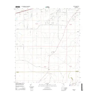
2015 Map of Manning
USGS Topo · Published 2015About this map
The S Prong Saint Marys River and the South Prong Saint Marys River define the northern hydrology of this Florida landscape, where Baker, Union, and Bradford Counties meet. The small settlements of Manning and Sapp anchor the central corridor, linked by a network of rural roads such as Clet Harvey Rd and Sapp Rd. Near the northern boundary, the Mantown Cem serves as a significant landmark for genealogical research. The presence of Southern States Nursery Rd and Ponsell Nursery Rd suggests a local economy tied to horticulture and silviculture. To the south, the New River provides a natural border between Bradford and Union counties, while smaller drainage features like Oak Br cross the terrain, illustrating the low-lying, water-dense character of this interior Florida region.
Find a feature on this map
77 named features on this map. Tap any name to fly to it.
Don’t see what you’re looking for? This feature index may not catch every label — zoom into the map to look around manually.
Map Details
Editions of this 2015 Manning Map
This is the sole edition of this map. No revisions or reprints were ever made.
Other maps of this area

1917 · Macclenny
USGS Topo · 1:62,500

1918 · Lawtey
USGS Topo · 1:62,500

1918 · Macclenny
USGS Topo · 1:62,500

1954 · Valdosta
USGS Topo · 1:250,000

1958 · Valdosta
USGS Topo · 1:250,000

1959 · Valdosta
USGS Topo · 1:250,000

1963 · Sanderson South
USGS Topo · 1:24,000

1966 · Lake Butler
USGS Topo · 1:24,000

1969 · Sanderson North
USGS Topo · 1:24,000
1970 · Lawtey
USGS Topo · 1:24,000