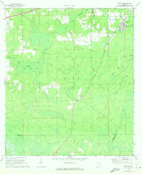
1970 Map of Manning
USGS Topo · Published 1973About this map
The Northeast Florida State Hospital complex dominates the northeastern corner of this 1970 landscape, where the Seaboard Coast Line railroad cuts a diagonal path through the dense wetlands of Baker and Union counties. This environment is defined by its water systems, notably the South Prong St Marys River and the vast Mud Lake Swamp, which illustrate the natural drainage patterns of the Florida interior before extensive modern development. Small settlements and rural community centers such as Manning and Sapp are situated along the rail line, while Manntown Ch and Raiford Road Ch serve as local anchors for the surrounding area. The transition from the Turkey Creek Swamp in the south to the headwaters of the New River provides a clear view of the region's complex hydrology and traditional transit corridors.
Find a feature on this map
21 named features on this map. Tap any name to fly to it.
Don’t see what you’re looking for? This feature index may not catch every label — zoom into the map to look around manually.
Map Details
Editions of this 1970 Manning Map
This is the sole edition of this map. No revisions or reprints were ever made.
Other maps of this area

1917 · Macclenny
USGS Topo · 1:62,500

1918 · Lawtey
USGS Topo · 1:62,500

1918 · Macclenny
USGS Topo · 1:62,500

1954 · Valdosta
USGS Topo · 1:250,000

1958 · Valdosta
USGS Topo · 1:250,000

1959 · Valdosta
USGS Topo · 1:250,000

1963 · Sanderson South
USGS Topo · 1:24,000

1966 · Lake Butler
USGS Topo · 1:24,000

1969 · Sanderson North
USGS Topo · 1:24,000
1970 · Lawtey
USGS Topo · 1:24,000