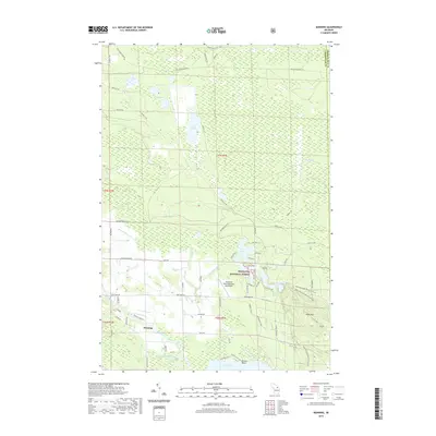
2019 Map of Manning
USGS Topo · Published 2019About this map
Hiawatha National Forest and the Black Mountain Recreation Area dominate this northern Michigan landscape, where dense marshlands meet the southern reaches of Black Lake. The settlement of Manning sits near the winding course of the Black River, a central artery for a region defined by complex hydrology, including the Alverno Swamp and Linsey Marsh. This 2019 survey documents a landscape where timber and recreation intersect, evidenced by the presence of Hoffman's Black Mountain Aerodrome and the Black Mtn summit. The mapping of Rail Road Grade Rd in the north provides a clear trace of the area's industrial past, marking the paths of former logging lines that once moved timber through the wetlands surrounding Duck Lake and Lake Sixteen. Local access points like Doriva Beach show the transition from protected forest land to residential lakeside living.
Find a feature on this map
71 named features on this map. Tap any name to fly to it.
Don’t see what you’re looking for? This feature index may not catch every label — zoom into the map to look around manually.
Map Details
Editions of this 2019 Manning Map
This is the sole edition of this map. No revisions or reprints were ever made.
Other maps of this area

1955 · Cheboygan
USGS Topo · 1:250,000

1957 · Tower
USGS Topo · 1:62,500

1957 · Cheboygan
USGS Topo · 1:62,500

1957 · Onaway
USGS Topo · 1:62,500

1958 · Cheboygan
USGS Topo · 1:250,000

1958 · Grace
USGS Topo · 1:62,500

1982 · Petoskey
USGS Topo · 1:100,000

1982 · Cordwood Point
USGS Topo · 1:25,000

1982 · Cheboygan
USGS Topo · 1:25,000

1982 · Grace
USGS Topo · 1:24,000