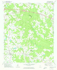
1972 Map of Mansfield
USGS Topo · Published 1974About this map
The Central of Georgia railroad corridor anchors this survey of Newton County, where small agricultural settlements and rural congregations define the landscape in the early 1970s. The town of Mansfield serves as a local hub, situated near Newborn and the Bethel Grove Ch. Further north, the namesake Brick Store settlement stands at a historical junction of local roads, while the Walton State Fish Hatchery utilizes the headwaters of the Little River. This sheet documents a rural Georgia interior before modern expansion, where family-named routes like Pitts Chapel Road and Jones Road connect isolated farms to landmarks such as Hays Pond and Shoal Creek Ch. The geography is further complicated by three county boundaries—Walton, Morgan, and Jasper—meeting near the eastern and southern margins.
Find a feature on this map
48 named features on this map. Tap any name to fly to it.
Don’t see what you’re looking for? This feature index may not catch every label — zoom into the map to look around manually.
Map Details
Editions of this 1972 Mansfield Map
2 editions found
Other maps of this area

1896 · Monroe
USGS Topo · 1:125,000

1953 · Athens
USGS Topo · 1:250,000

1958 · Athens
USGS Topo · 1:250,000

1959 · Athens
USGS Topo · 1:250,000

1963 · Athens
USGS Topo · 1:250,000

1964 · Stewart
USGS Topo · 1:24,000

1964 · Covington
USGS Topo · 1:24,000
1964 · Jersey
USGS Topo · 1:24,000

1971 · Rutledge North
USGS Topo · 1:24,000
1971 · Social Circle
USGS Topo · 1:24,000